Ex-tropical cyclone Alfred LIVE updates: Storm set to make landfall momentarily, heavy rainfall forecast for Brisbane, Gold Coast; NSW Northern Rivers flood risk elevated
Key posts
What we know so far
By Caitlin Fitzsimmons
If you’re just joining us, here is everything you need to know about ex-tropical cyclone Alfred.
- Tropical Cyclone Alfred was downgraded to a tropical low earlier on Saturday morning, but warnings remain in place for severe rain and flooding.
- The storm has stalled and is sitting over Bribie Island, but is expected to cross the mainland in the next few hours.
- Brisbane, the Gold Coast and northern NSW will be hit with heavy rain today.
- Floods are expected in the Northern Rivers and Mid North Coast regions of NSW, especially in Lismore and Bellingen.
- One man remains missing after his car was swept off a bridge yesterday.
- About 320,000 homes across northern NSW and South East Queensland remain without power, most of them north of the border. Several communities also have no telecommunications access.
- As reported in the blog yesterday, a rapid attribution study by scientists at ClimaMeter says ex-tropical cyclone Alfred was moving more slowly and dumping more rain because of human-caused climate change.
- Climate change is also expanding the range of cyclones and hurricanes further north and south of the equator.
Local services in Queensland – what’s working?
By Alexander Darling
In terms of life returning to normal in Queensland, here’s what Premier David Crisafulli just outlined:
- Buses: Normal Sunday timetables for Brisbane, Ipswich, Toowoomba and the Sunshine Coast, and Moreton Bay (excluding Bribie Island), and limited returns for Logan and Caboolture. No buses on the Gold Coast. Check the MyTranslink app from 6pm tonight.
- Trains: Unavailable Sunday, debris needs to be cleared from the tracks.
- Supermarkets: Some reopened today, more to open tomorrow.
- Ferry: Limited ferry services to Moreton Bay from tomorrow.
- Traffic lights: Fifty restored today, but around 50 per cent remain out on the Gold Coast and 16 per cent in Brisbane.
Emergency to continue for days: Queensland premier
By Alexander Darling
Queensland’s premier has thanked Queenslanders for displaying “common sense”, outlining services that will gradually come back online from tomorrow as ex-tropical cyclone Alfred moves inland.
But the weather event is far from over, with riverine and flash flooding now the main concern for authorities.
Locals venture out to Main Beach on the Gold Coast.Credit: Dan Peled
In his update, David Crisafulli confirmed power has just been restored to Gold Coast University hospital, and he praised the 2000 staff who stayed in Queensland’s health services overnight instead of at their homes to look after patients.
“At a time when staying at home would have been far and away that the option that they would have chosen, instead they chose you. They chose Queensland,” he said.
Around 267,000 properties remain without power, and Crisafulli said that the number of Queenslanders with no electricity peaked at 750,000 – the single largest loss of power from one weather event in Queensland’s history.
Minor flood warning for Brisbane CBD
By Cameron Atfield and Caitlin Fitzsimmons
There is a flood watch for Brisbane, but not yet a flood warning because of the high uncertainty about whether the rain will fall north, south or in the middle of the city.
Senior meteorologist Christie Johnson, from the Bureau of Meteorology, said there had only been 11 millimetres of rain in Brisbane since 9am today, but there could be 100-200 millimetres around the city and suburbs overnight and tomorrow.
“It will depend exactly on the track of Alfred, and it has been quite wobbly,” Johnson said. “If it went further northwards or further southwards, it could affect where that heaviest rainfall falls.”
She said the other source of uncertainty was the potential for thunderstorms to develop around this system, either today or tomorrow.
Forecast rainfall could also result in minor Brisbane River flooding between Lowood and Mount Crosby from late Sunday.
Rainfall, flooding ‘only just starting’
By Caitlin Fitzsimmons
Senior meteorologist Christie Johnson, from the Bureau of Meteorology, said the heaviest rainfalls today were “actually falling over the ocean”, but this would change as the storm moved inland.
On land, the highest rainfalls since 9am were over Queensland, especially the Gold Coast and hinterland.
“Most of the rainfall has been north of the border and that’s because Alfred moved a little bit further north … to Bribie Island,” she said.
There had been about 60 millimetres of rain in the Springbrook area, about 50 millimetres at Mount Glorious inland from Brisbane and about 40 millimetres in the Moreton Islands.
The heaviest rainfall in NSW today was between Grafton and Dorrigo – more Mid North Coast than Northern Rivers, though Mullumbimby had about 40 millimetres since 9am.
An isolated weather station at Lowanna in the Coffs hinterland recorded 100 millimetres, but had not yet been quality-controlled, Johnson said.
Grafton had about 50 millimetres since 9am, while just south of Grafton had 60-70 millimetres. Dorrigo had another 50 millimetres, which Johnson said came on top of 750 millimetres over the past few days.
Bellingen lies downstream from Dorrigo and the Bellinger River is prone to flooding. Some Bellingen residents on social media described today’s rain as “typical March weather” and suggested a beat-up.
However, Johnson said the tropical low was a significant weather event and tomorrow could actually be the wettest day in Bellingen and many other places, with the rainfall and flood risk continuing into early next week.
“It is only just starting really from a flooding perspective because … for many places [Sunday] is going to be the wettest day, or maybe even into the start of next week,” she said.
“A lot of people might be thinking ‘oh there’s not too much rain yet’, but the rivers are swollen, the catchments are wet, the ground is wet, and we’re expecting significant rainfall over the next 48 hours or so, so significant flood impacts are still to come and very, very likely.”
Queensland premier provides an update
Queensland Premier David Crisafulli is providing an update on the situation with ex-tropical cyclone Alfred.
You can watch it here.
Snow-like foam comes down on Gold Coast
By William Davis
Thick snow-like sea foam is dusting the streets of the Gold Coast.
Large crowds gathered at Main Beach this afternoon as heavy winds carried the salty, sandy substance into the sky.
“We’ve never seen it before, but it’s strange,” one onlooker said.
The footpath in front of the beach was severely undermined by erosion, and council workers were turning people away from about 3pm Queensland time. Police were also on the scene.
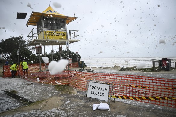
The flying sea foam, generated by strong winds from ex-tropical cyclone Alfred, at Main Beach on the Gold Coast.Credit: Dan Peled
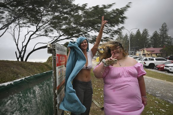
Winds continue to batter the Gold Coast
Our reporter William Davis is on the Gold Coast, where ex-tropical cyclone Alfred’s wrath continues to be felt.
He says while Brisbane has been spared the worst of Alfred, the wind – which is deafening – continues to batter the Gold Coast.
Grit and humour in the face of a cyclone
By Cameron Atfield
“We are Queenslanders; we’re the people that they breed tough north of the border. We’re the ones that they knock down and we get up again.”
That rallying cry echoed throughout the country in 2011 when then-premier Anna Bligh was confronted with catastrophic flooding that saw Brisbane go under water for the first time since 1974.
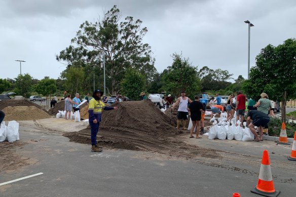
Sandbag-filling efforts at Murarrie Recreational Reserve, Wynnum Road, Murarrie as locals prepared for Alfred on Thursday.Credit: Tess Bennett
Fourteen years on, Bligh’s words still rang true as Queenslanders stood firm in the face of Cyclone Alfred – the first expected to cross the south-east coast in more than 50 years.
The threat of Alfred was met with calmness and good humour – the “blow at Cyclone Alfred to push it back” group on Facebook amassed more than 116,000 people in less than a week as the storm approached.
You can read more about how Queenslanders have been dealing with Alfred here.
What we know so far
By Caitlin Fitzsimmons
If you’re just joining us, here is everything you need to know about ex-tropical cyclone Alfred.
- Tropical Cyclone Alfred was downgraded to a tropical low earlier on Saturday morning, but warnings remain in place for severe rain and flooding.
- The storm has stalled and is sitting over Bribie Island, but is expected to cross the mainland in the next few hours.
- Brisbane, the Gold Coast and northern NSW will be hit with heavy rain today.
- Floods are expected in the Northern Rivers and Mid North Coast regions of NSW, especially in Lismore and Bellingen.
- One man remains missing after his car was swept off a bridge yesterday.
- About 320,000 homes across northern NSW and South East Queensland remain without power, most of them north of the border. Several communities also have no telecommunications access.
- As reported in the blog yesterday, a rapid attribution study by scientists at ClimaMeter says ex-tropical cyclone Alfred was moving more slowly and dumping more rain because of human-caused climate change.
- Climate change is also expanding the range of cyclones and hurricanes further north and south of the equator.
The latest from on the ground in Lismore
Our science reporter Angus Dalton is in Lismore for us.
Authorities there are now saying the Wilsons River levee bank should hold – at least for today.
Here is Angus’ latest report.
Most Viewed in National
>read more at © Sydney Morning Herald
Views: 0