Cyclone Alfred LIVE updates: Brisbane, south-east Queensland remain on high alert as storm’s landfall delayed; flooding expected in northern NSW
Good morning
Hello and welcome to our live coverage as Cyclone Alfred approaches the Queensland coast, triggering evacuation orders in northern NSW.
Here is a recap of key developments:
- Alfred is set to cross Queensland’s coast near Caboolture north of Brisbane around 8am on Saturday (AEDT), 24 hours later than initially predicted.
- The latest track map released by the Bureau of Meteorology shows the tropical cyclone’s anticipated landing time at 7am Saturday, Queensland time.
- The cyclone is expected to lash northern NSW and southeast Queensland with heavy rain and wind, forecast to peak late on Friday and early Saturday.
- The cyclone is set to trigger wind gusts up to 155km/h and 800mm of rain into the weekend from Brisbane to NSW’s Northern Rivers when it eventually arrives.
- Residents in certain parts of North Macksville, Macksville, Bowraville, Nambucca Heads and Gumma have been told to evacuate by 8am, Friday March 7 due to anticipated flooding.
- Schools, public transport, major roads and airports are closed, with elective surgeries also put on hold, but emergency departments remain open.
- Supermarkets have started to shut down across northern NSW and Queensland’s southeast as they brace for Alfred.
- The tropical cyclone will be the first to hit southeast Queensland and northeast NSW in more than 50 years.
New update from BOM
The Bureau of Meteorology has just released a new update on the tracking of Cyclone Alfred – and it could now hit a little earlier.
It said Alfred is slow-moving but is expected to make landfall along the southeast Queensland coast on Friday night or early Saturday morning, bringing flash flooding and destructive winds.
Residents on the Mid-North Coast, Northern Rivers and the Northern Tablelands, east of Tenterfield, should prepare for heavy rain, which could lead to flash flooding, the report released on Friday at 3am AEDT stated.
They should also brace for damaging winds with gusts of 100km/h possible across parts of the Northern Tablelands starting from Friday morning and continuing into Saturday.
On the Northern Rivers – as far south as Cape Byron – those gusts could reach 155km/h on Friday.
Areas of NSW in the direct path of the damaging winds and rain include Lismore, Grafton, Coffs Harbour, Tenterfield, Yamba, Woolgoolga, Sawtell and Dorrigo.
Airlines expect flight cancellations until Sunday
Jetstar, Qantas and Virgin Australian have cancelled flights to and from Brisbane, the Gold Coast and Ballina for Friday and Saturday.
Qantas said passengers should receive a text or email about their bookings, while a Virgin spokesperson said they were “proactively” reaching out to all impacted guests to re-book flights.
Virgin Australia said any passengers who were travelling to or from Ballina, Brisbane, Bundaberg, Gold Coast and Sunshine Coast airports between Tuesday March 24 and Monday March 10 inclusive can move their flight within 14 days of their original departure date free of charge, the ABC reported.
Qantas said any customers who were travelling on Queensland and northern NSW routes between Tuesday March 4 and Sunday March 9 would be offered flexibility on their ticket.
Power outages hit tens of thousands
Tens of thousands of people are without power across south-east Queensland and northern NSW.
In NSW, the outages are mostly concentrated between Tweed Heads and Ballina, but stretch down to Bulahdelah, south of Forster.
Essential Energy said about 10,000 homes and businesses in northern NSW have been impacted due to strong winds and heavy rainfall brought on by Cyclone Alfred. Power outages were most likely to increase substantially on Friday.
It warned power may remain disconnected for long periods of time as the dangerous weather hinders the ability of crews to survey or repair the damage.
“Crews are working to restore as soon as it is safe to do so as outages occur, with some locations unable to be accessed due to heavy rainfall flooding river crossings or water on the roads,” Essential Energy said.
The long wait for Alfred
Millions of people are sweating on Alfred’s arrival after the category two system stalled overnight.
Among them is Aaron Hawke who is in Alfred’s direct path in Brighton, just 30km from Caboolture in Queensland.
Alfred is set to cross Queensland’s coast near Caboolture north of Brisbane on Saturday morning, 24 hours later than initially predicted.

Sandbags are seen outside a business in Brisbane. Credit: Getty Images
For days Hawke and thousands like him have been bracing for the destructive winds, storm surges and flooding set to be triggered by Alfred.
Now he has 24 more hours to dwell on the danger after the system meandered.
“We had a fair bit of prep time, but the delay has added more anxiety because now there’s more time to sit around and wait for something you don’t know how bad it will be,” he told AAP.
The system is set to arrive under the cover of darkness in Saturday’s early hours, potentially causing rising floodwaters and storm surges.
“Imagine crawling around in the water with a torch in the middle of the night with winds howling, it doesn’t sound too much fun,” Hawke said.
with AAP
Cyclone Alfred’s arrival pushed back
Tropical Cyclone Alfred’s forecast arrival has been pushed back by 24 hours after the category 2 storm stalled off Australia’s east coast.
The track map released on Thursday night by the Bureau of Meteorology shows the cyclone’s landing time further delayed until 7am Saturday, Queensland time. Cyclone Alfred has dropped in speed to 6 kilometres per hour, and has remained the same distance from land since 5pm.
The cyclone was expected to cross the coast early on Saturday morning between Noosa and Coolangatta.
Forecasts suggest the cyclone could be downgraded in severity to a category 1 storm, but meteorologists warn the delayed landfall could prolong severe weather conditions and remain a major threat to communities.

The bureau’s Cyclone Alfred track map at 8pm Queensland time, Thursday night.Credit: Bureau of Meteorology
More regions in northern NSW told to evacuate
By Kayla Olaya
The NSW SES released a second round of evacuation notices for more areas in northern NSW, after telling residents in Lismore earlier to evacuate by Thursday night.
Residents in certain parts of North Macksville, Macksville, Bowraville, Nambucca Heads and Gumma have been told to evacuate by 8am Friday, March 7.
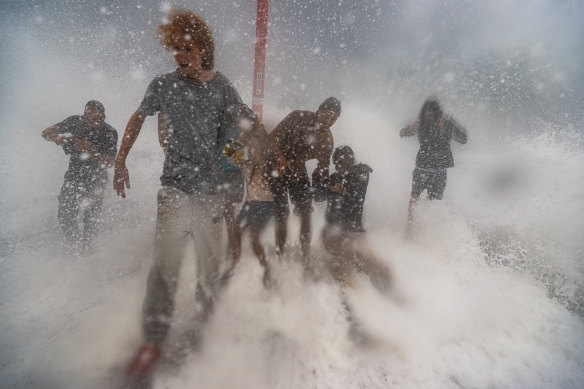
People are almost washed off the Brunswick Heads rockwall on the NSW north coast as Alfred moved closer.Credit: Nick Moir
“You must evacuate before this time because forecasted heavy rainfall will close evacuation routes,” the SES said.
“If you remain in the area, you may become trapped without power, water, and other essential services. It may be too dangerous for NSW SES to rescue you, and buildings may not be able to withstand the impact of flood water.”
Specific roads and streets have been told to evacuate, and can be found here.
Good morning
Hello and welcome to our live coverage as Cyclone Alfred approaches the Queensland coast, triggering evacuation orders in northern NSW.
Here is a recap of key developments:
- Alfred is set to cross Queensland’s coast near Caboolture north of Brisbane around 8am on Saturday (AEDT), 24 hours later than initially predicted.
- The latest track map released by the Bureau of Meteorology shows the tropical cyclone’s anticipated landing time at 7am Saturday, Queensland time.
- The cyclone is expected to lash northern NSW and southeast Queensland with heavy rain and wind, forecast to peak late on Friday and early Saturday.
- The cyclone is set to trigger wind gusts up to 155km/h and 800mm of rain into the weekend from Brisbane to NSW’s Northern Rivers when it eventually arrives.
- Residents in certain parts of North Macksville, Macksville, Bowraville, Nambucca Heads and Gumma have been told to evacuate by 8am, Friday March 7 due to anticipated flooding.
- Schools, public transport, major roads and airports are closed, with elective surgeries also put on hold, but emergency departments remain open.
- Supermarkets have started to shut down across northern NSW and Queensland’s southeast as they brace for Alfred.
- The tropical cyclone will be the first to hit southeast Queensland and northeast NSW in more than 50 years.
Most Viewed in National
>read more at © Sydney Morning Herald
Views: 0